Sunday Night through Tuesday Event
Follow my Facebook Group!
Sunday Night through Tuesday Event
1:00PM SUNDAY - This is a VERY tricky forecast. Any wobble in the track by 30-50 miles will make a hell of a difference with this storm. I'm going to break it all down for you below.
Scattered rain and snow showers will move in after midnight tonight. The first part of the storm will not be anything more than a nuisance. Showers of rain and snow will stick around through the morning on Monday. I want to emphasize that they will be scattered. So there will be dry periods. It's not really an organized area of precipitation that will be moving through.
During the afternoon on Monday, showers of rain and snow will become steadier (especially the further East you are located). After dark, snow and rain will continue to increase intensity. The further south you are located, the better chance you have at seeing rain. Also, some lower elevations further north may even see periods of rain. The highest elevations stand the best chance at staying ALL SNOW through the event.
After midnight into early Tuesday morning, snow will fall at rates of 1-2 inches per hour. Again, the further east you are, the heavier your snow. If you are located in western portions of the viewing area, you may not really cash in on snow bands Tuesday. These snow bands are from the Nor'easter moving up the coast.
Moderate snow looks to stick around for most of the day on Tuesday. Especially East of the I-81 corridor. Everything should wrap up late Tuesday evening as the storm pulls away.
I want to inform you on gusty winds as well. With a Nor'easter, very gusty winds are likely. I'm expecting winds to really start cranking AFTER midnight Tuesday morning. Gusts could hit 40mph at times. Gusty winds will be with us all day Tuesday. Watch for blowing and drifting snow.
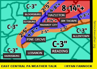
Below is my snow map for East Central PA:
CLICK IMAGE TO VIEW LARGER

.jpg)


